Vietnam Fighting Sea Level Rise: Victim or Enabler?


Pamela McElwee

In the 2014 film Nước 2030, rising sea levels have completely submerged Hồ Chí Minh City, and the region’s residents must now survive on small rickety boats or labor on floating farms owned by foreign multinationals.  Billed as the first sci-fi film from Vietnam, Southeast Asia’s future is a watery dystopia. Fights break out over who, if anyone at all, has rights to the resources of the aqueous environment, and if ancestral lands lying underneath the sea still bestow access rights. Shady corporations invest in desalinization technologies and experiment with genetically modified plants that will tolerate the saltwater, while former farmers cope with their future on water, isolated from their previous communities and unable to perform even basic cultural rites like traditional burials.

Still from Nước 2030

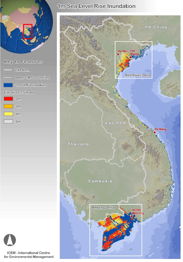
Although wildly speculative, Nước 2030 draws attention to the fact that coastal areas of Asia are extremely vulnerable to climate change-induced sea level rise (SLR). While smaller, island states have received most of the world’s notice, in fact littoral Asia is home to much larger populations facing rising waters. The World Bank has designated Vietnam as one of the top 5 countries in the world threatened by global SLR, with “potentially catastrophic” consequences. The Mekong Delta, known as the rice basket of the country, faces the possibility of a 40% loss in land area if sea level rises one meter, currently an entirely plausible forecast for the end of this century. In just thirty years in Hồ Chí Minh City (HCMC, the former Saigon), the country’s largest and richest city, 60% of all citizens will face more extreme flooding as a result of SLR. To combat these future nightmare scenarios, Vietnam has become a prominent member of the Climate Vulnerable Forum of 40+ at-risk countries, and has requested billions of dollars of international aid for adaptation, much of it directed at holding back the rising seas.

Yet Vietnam’s vulnerability is not just a result of anthropogenic climate change caused by greenhouse gas emissions generated elsewhere. Too often, countries argue for placement in a ‘victim slot’ without a harder look at their own culpability. In Vietnam’s case, SLR is a growing problem, but so too is unregulated coastal zone and urban development. Rapid economic growth in the past three decades has degraded ecosystems, reduced resilience, and concentrated assets in coastal areas and floodplains, placing them at risk. Most of Vietnam’s largest cities (Hànội, HCMC, Đà Nẵng, Cần Thơ and Huế) are either directly on or less than 100 km from a coastal zone. A further important concern is the country’s chaotic use of groundwater, with excessive rates of abstraction due to unregulated private borewells, leading to serious consequences for land subsidence. While some land sinking (subsidence) can occur naturally, rates increase when groundwater aquifers are depleted and the layers on top undergo compaction, leading to depressions at the land surface. These ill-considered governmental and individual decisions to exploit water tables and build up coastlines now clash with the realities of global climate change’s impact. The problem is, Vietnam is not yet asking how its development trajectories and environmental governance systems must be radically reconfigured in a world that will likely be 2 or more degrees warmer.  


Given its 3400-km long coastline, physical geography strongly exposes Vietnam to SLR. River deltas in North and South give Vietnam the appearance of two baskets on a carrying pole; land elevation in the Mekong Delta averages only 0.8m above sea level. Observed sea levels, measured both by tidal gauges and satellites, have risen along the coastline of Vietnam in the 20th century by around twenty cm, and continue to rise 3mm per year.

Higher rates of SLR mean more coastal erosion and inundation, with reductions of per capita land availability and physical displacement. It also means increased risk from storm surges accompanying hurricanes; more frequent coastal flooding; infrastructure losses, such as roads and bridges that are reclaimed by the sea; and increasing salinization of freshwater sources further inland. Excess salinity kills rice and shrimp fry, two of Vietnam’s prime agricultural exports; in the Mekong Delta, hundreds of thousands of hectares of agricultural fields will be rendered useless when SLR reaches even 30 cm. SLR of 1 meter will destroy 19,000km of roads, costing over $2 billion US to replace.

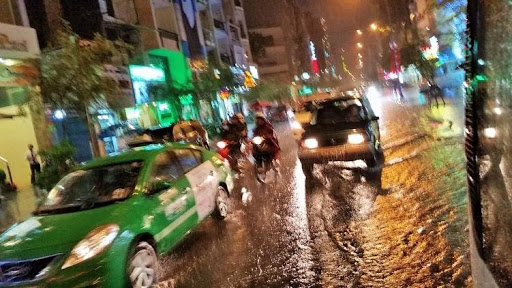
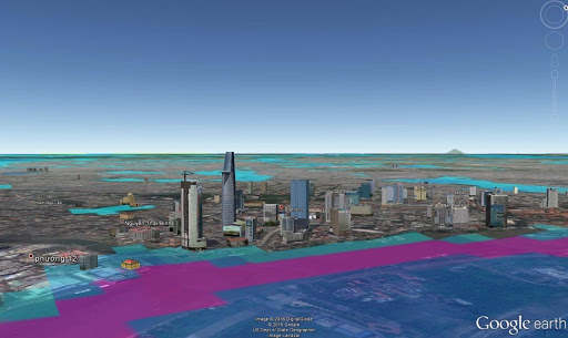
In some ways, the future has already arrived. Salinity intrusion has spread 30-50 km inland in the Red River Delta and 60-70 km in the Mekong Delta, and has already polluted thousands ha of land. In the last few years, scores of households in the Mekong Delta were affected by severe coastal erosion, losing land and houses to ocean tides at a rate of nearly 2.3 km2 a year. An additional driver of this process is loss of sediment deposition due to upstream dams (attributed to other countries’ hydropower development) and mining of riverbank sand and loss of protective mangroves downstream, for which Vietnam has only itself to blame. Already there is evidence of climate-related outmigration from the rural Delta to HCMC, but even there climate refugees cannot escape the future. The majority of the city is at risk of inundation from floods, which are exacerbated by SLR.
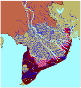
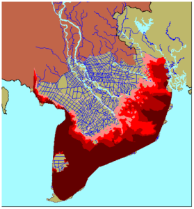
In 2000

With 1m SLR

Salinity boundary    
< 1 g/L1- 4 g/L4- 15 g/L> 15 g/L

Figure 1.  Salinity boundary in Mekong River delta in 2000 and projected for 1m SLR. Source: World Bank 2010

Most models for Vietnam predict SLR of 35 cm by 2050 under medium emissions scenarios, and a high-end estimate of 1m or more by century’s end or more cannot be ruled out. A 1m rise would partially inundate 7% of Vietnam’s land area and 11% of the total population, including 40% of the Mekong River Delta. High end scenarios show Vietnam will incur costs of $65 billion USD per year from SLR alone. Should sea level rise as high as 5m, although unlikely to happen for several centuries, more than a third of the country’s population would be in harm’s way.

Source: ICEM, 2008

However, the rates for SLR, as alarming as they are, are actually worse than they seem when they are added to subsidence (land sinking) rates. Excess groundwater extraction and overdevelopment is causing the Mekong Delta to sink 1.6 cm per year, a rate five times faster than SLR. The Mekong Delta is on track to expect on average 0.88m (and potentially up to 1.4 m) of land subsidence by 2050. The process cannot be reversed, as most of the groundwater extraction taps aquifer layers at a 50- to 120-m depth, which do not get seasonally recharged. Subsidence is worsened in built up areas, compacting soils underneath; for comparison, natural and unaltered ecosystems are not experiencing high rates of subsidence. Sand mining and loss of sedimentation due to upstream dams exacerbate the problem as well. All of this has an effect on water movement throughout the region: as one report notes, even “modest deformation due to human activities can change flooding conditions over large areas.” One dire projection is that the combined impacts of anthropogenic climate change with overdevelopment of the Mekong run the risk of wiping the delta completely off the map by 2100.

Most of Vietnam’s subsidence problem has happened in just the last 25 years. Overall, it is driven by lack of access and affordability of treated surface water supplies and piped water systems, leaving households to hire wildcat drillers to drive private wells deep into the water table. Just as in the West, where driving cars contributes to greenhouse case emissions, the aggregate actions of millions of Vietnamese citizens drilling wells has made the problem worse. 

The twin threats of SLR and subsidence pose a particularly existential threat to HCMC, Vietnam’s largest urban area, with nearly 9 million residents as of 2019. Rapid population growth has contributed to unplanned development on the peri-urban fringe and haphazard conversion of formerly agricultural lands; a number of service provision problems, particularly related to drinking water and sewer/drainage access; and substandard housing. While the city is not directly on the coast, tidal surges on the Saigon River push water up into the city, increasing already dangerous flood-tide levels that quickly overtop the existing dike system. About 60% of the city is less than 1.5 m above sea level, and in the past 50 years, 20cm of SLR has been recorded on the southern coast. 


Street Flooding in Ho Chi Minh City. Photo by SqueakyMarmot, Creative Commons

A SLR of just 50 cm would lead to regular flooding of 300 km2 of the city, with up to 71% of land area and 62% of the population being regularly exposed. Low-lying wards, many of which are slum areas occupied by informal settlements and migrants, are at particular risk of flooding. The city also continues to add middle-class and upper-class housing by expanding to new urban areas (such as Saigon South and Thủ Thiêm), which were unwisely built on filled-in wetlands, and which also have higher flood risk. With a future 1m SLR, 6% of the land area, 15% of infrastructure, and many of the industrial zones and manufacturing facilities that ring around the city would be completely inundated. SLR will also increase salinity of the shallow coastal aquifers, making water supplies, for which households have exacerbated the subsistence problems, essentially undrinkable. These challenges are why HCMC is listed among the 10 port cities in the world most at risk from climate change.  

Flood maps overlaid with the built environment in Ho Chi Minh City, for a 25-year return period under high SLR. Source: Bangalore et al. 2017

As with the Mekong Delta, in HCMC, land subsidence amplifies the flood risks and damages roads and buildings. Many of the city’s districts are sinking at a speed of 15-45 mm/year. Piped water is available in nearly all districts, but is often weak and more expensive, so many households and buildings use illegal groundwater pumps, with over 200,000 known boreholes. Whereas in the 1950s groundwater abstraction was approximately 80,000 m3/day, it was 583,000 m3/day in 2008: the safe level of abstraction is less than 300,000 m3/day. Although the city government passed a Water Act in 2007 to better regulate groundwater use, it has been ineffectively enforced. Ultimately, the choices of where to build up, and how to supply water, are likely to be significantly more important than SLR in terms of long-term risks to HCMC. 

The national government has developed a National Climate Strategy, which focuses on three priority areas action: responding pro-actively to disasters and improving climate monitoring; ensuring social security; and responding to sea level rise and urban inundation. Many of the priority measures for SLR tend to be ‘hard’ adaptation: constructing urban drainage infrastructure and rural canals and sluices; major building projects like deeper ports; and strengthening and expanding sea and river dikes. Even a hugely expensive tidal barrier at the mouth of Saigon river (like the Thames Barrier in London) has been suggested. 

Unfortunately, large-scale adaptation measures are the least likely to be pro-poor; many times, the poorest households are those who are displaced by newly built infrastructure, or are excluded from access to the benefits of development. Further, hard adaptation measures often involve serious trade-offs. Sea dikes can result in simply shifting risk into other areas. For HCMC, a ring dike would protect the inner city but increase risk in more rural districts. Simpler measure like elevating buildings in areas at risk and dryproofing them would benefit more people. In the rural Delta, low tech actions like collecting rainwater or adopting alternative wetting and drying methods for rice growing can help as much or more than dikes.

The meta-challenge for Vietnam is that climate change will contradict development trajectories set by state authorities; right now, current economic growth always trumps future climate risk. Decisions made every day regarding how Vietnam should develop have put more people, assets, and resources in harm’s way. Managing this risk requires an understanding that tinkering around the edges with adaptation projects will not be enough, and that hard decisions about strategic priorities must be made. Not taking action now to limit development within areas known to be especially vulnerable to climate impacts, or to regulate groundwater abstraction, may mean that the country faces enormous costs of resettlement down the road. Coastal withdrawal and retreat, abandoning a site and moving elsewhere, is a very real possibility, even for large cities. The recent decision to move the capital of Indonesia from Jakarta due to subsidence, pollution and overcrowding provide a foreshadowing of what may face HCMC in the future under SLR.

While HCMC will not be an underwater graveyard anytime soon, the vision of the film Nước 2030 shows the madness of ignoring the very real risks that climate change and unsustainable development pose. The filmmaker has said that he made a documentary of the future. At the current trajectory that Vietnam is on, he is largely right.